4th Century
Remains of a Roman villa of considerable size situated 1/2 mile SE of (Foxcote) church and close to a stream. Excavated in 1837-40; the finds included baths with leaden pipes, two tessellated pavements, a walled bank, many small items and coins dating occupation to the early 4th century AD. One of the pavements may be seen at the ‘Queen’s Temple’ (SP 63 NE 15) in Stowe Park
Roman pottery has also been found at other locations, particularly when digging for the Hyde Lane and Foxcote reservoirs, but this is not unexpected as two Roman roads run through Foscott parish.
11th Century Doomsday Entry
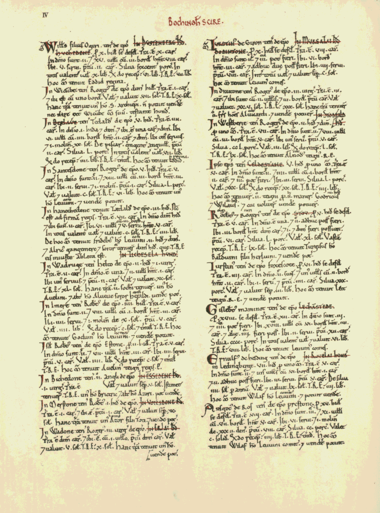
Foxecote was a settlement in Domesday Book, in the hundred of Stotfold and the county of Buckinghamshire.
It had a recorded population of 4 households in 1086, putting it in the smallest 20% of settlements recorded in Domesday.
Land of Bishop Odo of Bayeux
Households
Households: 1 villager. 2 smallholders. 1 slave.
Land and resources
Ploughland: 4 ploughlands. 2 lord’s plough teams. 2 men’s plough teams.
Other resources: Meadow 4 ploughs. Woodland 30 pigs.
Valuation
Annual value to lord: 3 pounds in 1086; 3 pounds when acquired by the 1086 owner; 3 pounds in 1066.
Owners
Tenant-in-chief in 1086: Bishop Odo of Bayeux.
Lord in 1086: Turstin.
Overlord in 1066: King Edward.
Lord in 1066: Leith, a royal thane.
12th Century
The church is the oldest standing building, having been started in the twelfth century and added to with a chancel in the fourteenth and a porch in the fifteenth centuries. It was converted to a house in the 1970s. In between the former church and the former manor house, which is now a younger building, there are earthworks of what appear to be medieval house platforms. The village of Foscott was slightly larger in the medieval period, it seems. Medieval ridge-and-furrow has been identified outside the village on aerial photographs. There is a historical reference to a Totes Bridge in the fourteenth century, which now has an eighteenth century casing.
17th Century
What was the former manor house is a seventeenth century building with alterations in the eighteenth, nineteenth and twentieth centuries. The gardens and parkland around date to the nineteenth century, though they have seen some alterations. There are seventeenth century records of the rectory having a pottery kiln in its grounds. The Grand Junction Canal, built in stages between the eighteenth and nineteenth centuries, also passes through the parish.